

Mission
Terra Flamma is a documentary journalism project photographing wildfires, the most acute effect of drought, climate change, and human sprawl in California and beyond. “Terra Flamma” is a rough Latin translation for “earth on fire.” The aim of the project is to photograph fires in a different way, one that makes a viewer examine the image and perhaps pique their interest and educate themselves more on wildfires and the forces behind them.
Terra Flamma also seeks to create a visual record of wildfires in the American West as wildfire season becomes year-round, and fires burn hotter, faster, and more destructively. Additionally, the images seek to raise awareness amongst homeowners and other stakeholders about wildfire emergency preparedness.
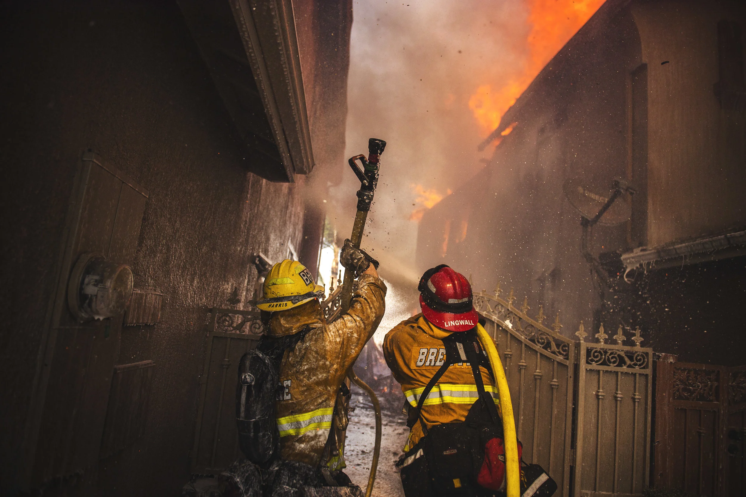
Finally, Terra Flamma seeks to share the work of men and women on the fireline, the wildland firefighters and those who support them. They toil for weeks at a time, working with little rest in hot, dry, and dusty conditions. They eat MRE’s while swinging handtools in all sorts of terrain and smile while doing it (usually!). Many are seasonal workers without full-time employment, yet they still risk their lives every day when fighting fire.

Valley Fire, July 2018
Objectives
Create a visual record of wildfire
- Drought
- Climate Change
- Wildland Urban Interface (WUI) challenges
- Increased fire danger Year-round
Share the work of firefighters
- Tens of thousands of men and women toil in heat and ash amidst danger to save communities, restore forests, and keep the public safe. Let's thank them.
Raise public awareness
- Maintaining defensible space
- Hardening your home
- Staying aware and following evacuation orders
- The 5 P's, Papers, Plastic, People, Pets, Pills
Provide fire agencies, stakeholders, and media thoughtful + accurate coverage
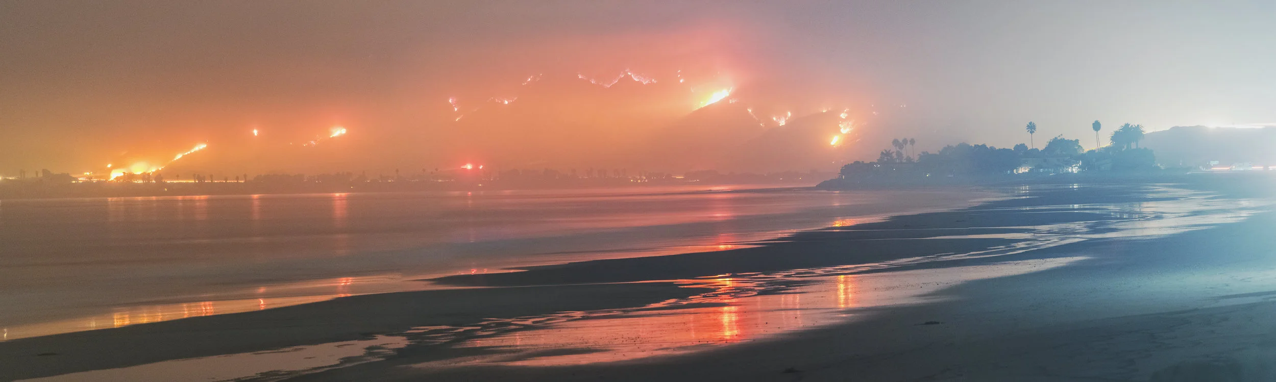
Thomas Fire, December 2017
On Climate Change
The entire American West is getting hotter and drier, with an average of 9 more high fire danger days per year (Westerling et al 2006). Average summer temperatures during the height of fire season in the West are increasing as well, with record hot days and months peppering states like California, Oregon, and Washington. As I write this essay on November 22nd, 2017, dozens of daily high temperature records were broken across California, with 14 in the National Weather Service Los Angeles forecast area alone. The highest was Camarillo airport at 99 degrees, which also broke the monthly record (NWS Los Angeles 2017). On Thanksgiving, November 23rd 2017, downtown Los Angeles recorded a record high temperature for that day of 91 degrees, breaking all temperature records for that day kept since 1877. Hotter weather dries out vegetation faster, and allows it to burn more easily in the afternoons as moisture is sapped.
A recent study estimates that “human-caused climate change contributed to an additional 4.2 million ha (hectacres) of forest fire area during 1984–2015, nearly doubling the forest fire area expected in its absence,” and also found it the culprit for over half the “increased fire-season fuel aridity, fostering a more favorable fire environment across forested systems” (Abatzoglou and William, 2016). The study looked at forested areas, and not necessarily at the Chaparral brush so prevalent at lower elevations in Southern California. It does apply to mid elevation pine forests such as those found in the San Bernardino, Angeles, Cleveland and Los Padres National Forests.
Acres Burned in California by Wildfire Over Last 25 Years
Welcome to the new normal.

The Wildland Urban Interface (WUI)
In California, luxury homes have been built in the last century on what used to be ranchland, on tops of hills, perched overlooking canyons, and at the ends of natural wind funnels like Santa Ana, Fremont, Santiago, and Modjeska Canyons in Southern California, just to name a few. While humans have changed the landscape, the weather and winds remain. These areas that blur the boundary between developed urban areas, suburbs, and the wilderness are what is known at the Wildland Urban Interface, or “WUI” in wildfire parlance. The WUI can include tightly packed subdivisions abutting chaparral or forested areas in Los Angeles, or bigger lots of ranch homes built within the forest, or anywhere else human development meets open land with vegetation.
Throughout the state, millions of California residents live in the WUI and are at risk from large wildfires. Firefighter’s worst fears were realized in October 2017 when the Tubbs Fire began outside of Santa Rosa north of San Francisco. Within hours thousands of homes and business were burning down and dozens had perished. As one Cal Fire wildland fire battalion chief who’d spent his career in and around Santa Rosa said, “These are the kinds of worst-case scenario fires you talk about around the dinner table… they happened all at once."

Tubbs Fire, October 2017
Prints
—
Support Terra Flamma
